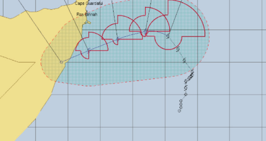
Mogadishu (HAN) December 7th, 2019 – Regional Climate crisis. According to Down to Earth report: Cyclone Pawan, 8th of this year forms in Arabian Sea.
With the formation of cyclone Pawan on the morning of December 5 in the southwest Arabian Sea, the total number of cyclones in the North Indian Ocean region this year has reached eight.
Climate Impact: Pawan joins Kyarr, Fani, Maha, Vayu, Hikaa, Bulbul and Pabuk; to cross the Horn of Africa, specially Somali peninsula on December 7th, 2019.
This is the highest number of cyclones in a single year since 1976, when nine cyclonic storms had formed in the region, according to data from the India Meteorological Department (IMD). This record might still be equalled as the IMD is tracking another depression in the east central Arabian Sea, though the system has weakened from a deep depression and is likely to de-intensify further in the coming days.
Six of the cyclones this year were of the ‘Severe’ or ‘Higher’ category. While Cyclone Kyarr in October reached super cyclone intensity with wind speeds in excess of 250 kilometres per hour (km/hr), Cyclone Fani in April-May and Cyclone Maha in October were of the ‘Extremely Severe’ category, with wind speeds greater than 200 km/hr.
Cyclone Vayu, Cyclone Hikaa and Cyclone Bulbul were of the ‘Very Severe’ category. There were six ‘Severe’ cyclones in 2018 as well. The last time there were more than five ‘Severe’ cyclones in two consecutive years was 1976-77 when seven and five ‘Severe’ cyclones formed respectively, according to IMD data.
Pawan will not intensify further, according to the latest press release by IMD. It will maintain its intensity till the morning of December 6 and gradually weaken thereafter. The IMD has not issued any rainfall warning for mainland India or Eastern Africa, though it has predicted strong winds in the coastal areas and seas surrounding them.
The Arabian Sea has seen a lot of cyclonic activity in 2019. Five of the eight cyclones this year formed in this region, the highest in the past 117 years. Four of these were severe cyclones, which last occurred in 1902. Only one of these cyclones, Maha, had an impact on the mainland, with heavy rainfall in Gujarat and Maharashtra. The rest of the cyclones formed, developed and dissipated in the sea.
On the other hand “the activity over the Bay of Bengal has been subdued this year as compared to Arabian Sea with the formation of only three cyclones (Pabuk, Fani, Bulbul) against the normal of four per year”, the IMD press release said.
However, two of three cyclones that did form, caused massive destruction. Cyclone Fani, which hit the Odisha coast in May, killed 70 people and caused economic losses of close to Rs 25,000 crore. Cyclone Bulbul, which made landfall along the West Bengal coast, killed 38 people and caused infrastructure damage worth Rs 23,000 crores.
There could be multiple reasons for this enhanced cyclonic activity. The first could be the active phases of both, the Indian Ocean Dipole and Madden Julian Oscillation phenomena. The second could be global warming, which has led to warmer-than-usual temperatures on the surface of seas and oceans.
This provides the perfect conditions for the formation of low pressure areas which can intensify into depressions and further into cyclones.
In September, the World Meteorological Organization (WMO) had said that the world will be witness to warmer-than-usual surface and sea temperatures in the latter part of 2019. It had also said that this was a clear sign of global warming in the absence of the El Nino phenomenon, which had ended in August.
“Even so-called El Nino Southern Oscillation (ENSO) neutral months are warmer than in the past as air and sea surface temperatures and ocean heat have increased due to climate change,” a WMO press release had said at the time.
Also according to the WMO, the leaning towards above normal temperatures was particularly strong in tropical and sub-tropical regions like India. “This could mean favourable conditions for the formation of cyclones in the Indian Ocean region as this is also the usual cyclone period,” UC Mohanty, an expert on wind systems and visiting professor at the School of Earth, Ocean and Climate Sciences at Indian Institute of Technology, Bhubaneswar had told Down To Earth. His prediction turned out to be true.
Source: Down to Earth
Leave a Reply